
Značilnosti kraških jam, zbrane na podlagi raziskav mikrotremorjev: študija primera jame Cerme, Yogyakarta, Indonezija
DOI:
https://doi.org/10.3986/ac.v52i1.10987Ključne besede:
microtremor, karst, Cerme Cave, amplification, Poisson'a ratioPovzetek
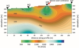
Raziskava mikrotremorjev, ki temelji na pridobivanju podatkov o površini tal, je podlaga za opredelitev in opis kraškega območja jame Cerme v Yogyakarti v Indoneziji, in sicer od vhoda v jamo do izhoda iz nje. Vhod v jamo in izhod iz nje sta uporabljena kot povezni točki, saj je mogoče značilnosti obeh lokacij opazovati neposredno. Parametri, uporabljeni v tej študiji, vključujejo okrepitev vibracij tal, hitrost strižnega valovanja in Poissonovo razmerje. Prisotnost votlin je mogoče opredeliti z razmeroma močnim kontrastom med temi fizikalnimi parametri in njihovo okolico. Izhod iz jame, ki se lahko obravnava kot vrtača, ima prevladujočo frekvenco od 3,2 do 4,6 Hz, ki je razmeroma višja od frekvence okolice. Na vhodu v jamo Cerme, kjer je velika votlina, je bilo zaznano majhna okrepitev vibracij tal, tj. manjša od 0,1. Na vhodu v jamo in izhodu iz nje je tudi majhna hitrost širjenja strižnega valovanja, tj. manjša od 350 m/s. Prisotnost podzemnega rečnega kanala v jami Cerme je mogoče opredeliti z visokim Poissonovim razmerjem 0,4 do 0,5, vrednostjo okrepitve manj kot 0,1 in hitrostjo strižnega valovanja manj kot 350 m/s.
Prenosi
Literatura
Arai, H., Tokimatsu, K., 1998: Evaluation of local site effect based on microtremor H/V spectra. The Effect of Surface Geology on Seismic Motion, -Balkema, Rotterdam
Azimmah, A., Widodo, 2017: Analysis of Ground Penetrating Radar’s Capability for Detecting Underground Cavities: A Case Study in Japan Cave of Taman Hutan Raya, Bandung. -IOP Conf. Series: Earth and Environmental Science 62 -012030. Doi :10.1088/1755-1315/62/1/012030
Balkaya, C., Göktürkler, G., Erhan, Z., Ekinci, Y.L., 2012: Exploration for a cave by magnetic and electrical resistivity surveys: Ayvacık Sinkhole example, Bozdağ, İzmir (western Turkey). -GEOPHYSICS. Volume 77, Issue 3. https://doi.org/10.1190/geo2011-0290.1
Braitenberg, C., Sampietro, D., Pivetta T., Zuliani, D., Barbagallo, A., Fabris, P., Rossi, L., Fabbri, J., Mansi, A.H., 2016: Gravity for Detecting Caves: Airborne and Terrestrial Simulations Based on a Comprehensive Karstic Cave Benchmark. -Pure and Applied Geophysics volume 173, 1243–1
Ezersky, M.G., Legchenko, A., Eppelbaum, L., Al-Zoubi, A., 2017: Overview of the geophysical studies in the Dead Sea coastal area related to evaporite karst and recent sinkhole development. -International Journal of Speleology, 46 (2), 277-302. https://doi.org/10.5038/1827-806X.46.2.2087
Fabrizio, C., Cultrera, G., Azzara, RM., Valerio, DR., Giuseppe, DG., Giammarinaro, MS., Tosi, P., Vallone, P., Rovelli, A., 2008: Microtremor Measurements in the City of Palermo, Italy: Analysis of the Correlation with Local Geology and Damage, -Bulletin of the Seismological Society of America, 98 (3): 1354-1372
Gercek, H. 2007: Poisson’s ratio values for rocks. -International Journal of Rock Mechanics and Mining Sciences, 44(1): 1–13. doi:10.1016/j.ijrmms.2006.04.011.
Gibson, P.J., Lyle P., George M., 2004: Application of resistivity and magnetometry geophysical techniques for near-surface investigations in karstic terranes in Ireland. -Journal of Cave and Karst Studies, 66 (2): 35-38.
Goa Cerme Yogyakarta. http://asc.or.id/asc-jogja/cave-tourism-2-cerme [accessed June 14, 2020]
Hamdan. H., Economou, N., Kritikakis, G., Andronikidis, N., Manoutsoglou, E., Vafidis, A., Pangratis, P., Apostolidou, G., 2012: 2D and 3D imaging of the metamorphic carbonates at Omalos plateau/polje, Crete, Greece by employing independent and joint inversion on resistivity and seismic data. -International Journal of Speleology, 41(2), 199-209. http://dx.doi.org/10.5038/1827-806X.41.2.7
Hartvich, F., Valenta, J., 2011: The identification of faults using morphostructural and geophysical methods: a case study from Strašín cave site. -Acta Geodyn. Geomater., 8 (4 -164): 425–441
Haryono, E and Day, M. 2004: Landform differentiation within the Gunung Kidul Kegelkarst, Java, Indonesia. -Journal of Cave and Karst Studies, v. 66, no. 2, p.62-69.
Huang, S., Lin, J., Huang, Q., Liang, R., 2020: An emerging method using Electromagnetic wave computed tomography for the detection of karst caves. -Geotechnical and Geological Engineering volume 38, pages 2713–2723
Hussain, Y., Uagoda, R., Borges, W., Nunes, J., Hamza, O., Condori, C., Aslam, K, Dou, J., Cárdenas-Soto, M., 2020: The potential use of geophysical methods to identify cavities, sinkholes and pathways for water infiltration. -Water, 12, 2289; doi:10.3390/w12082289
Kasprzak, M., Sobczyk, A., Kostka S., Haczek A., 2015: Surface geophysical surveys and LiDAR DTM analysis combined with underground cave mapping – an efficient tool for karst system exploration: Jaskinia Niedzwiedzia case study (Sudetes, SW Poland). -Geomorphometry for Geosciences, Jasiewicz J., Zwolinski Zb., Mitasova H. , Hengl T. (eds), 2015. Adam Mickiewicz University in Poznan Institute of Geoecology and Geoinformation , International Society for Geomorphometry, Poznan
Keceli, A., 2012: Soil parameters which can be determined with seismic velocities. -Jeofizik, 16, 17-29
Kolesnikov, Y.I., Fedin, K.V. 2017: Detecting underground cavities using microtremor data: physical modelling and field experiment. -Geophysical Prospecting, Volume 66, Issue 2, p. 342 – 353. DOI: https://doi.org/10.1111/1365-2478.12540
Lay, T and Wallace T.C., 1995: Modern Global Seismology. Academic Press. San Diego California, USA
Mirzaoglu, M., Dykmen, U., 2003: Application of Microtremor to Seismic Microzoning Procedure, -Journal of The Balkan Geophysical Society, Vol.6 No.3. 143 – 156
Nagao, T., Hakoda, T., Ito, Y., Yamada, M., Nishibata, K,, Tsuda, A., 2017: A fundamental study of a cave detection method in coastal area using microtremor array measurements. -Journal of Japan Society of Civil Engineers Ser B3 (Ocean Engineering) 73(2):I450-I455. DOI: 10.2208/jscejoe.73.I_450
Nakamura, Y. 1989: A Method for Dynamic Characteristics Estimations of Subsurface Using Mikrotremors on the ground Surface QR RTRI 30 pp. 25-33
Nakamura, Y., Sato, T., Nishinaga, M., 2000: Local Site Effect of Kobe Based on Microtremor Measurement. Proceeding of the Sixth International Conference on Seismic Zonation EERI, Palm Springs California.
Nehmé, C., Voisin, C., Mariscal, A., Gérard, P.C., Cornou, C., Jabbour-Gédéon, B., Amhaz, S., Salloum, N., Badaro-Saliba ,N., Adjizian-Gerard, J., Delannoy, J.J., 2013: The use of passive seismological imaging in speleogenetic studies: an example from Kanaan Cave, Lebanon. -International Journal of Speleology, 42 (2) 97-108. Tampa, FL (USA) ISSN 0392-6672 http://dx.doi.org/10.5038/1827-806X.42.2.1
Nogoshi, M., Igarashi, T., 1971: On the amplitude characteristics of microtremor (Part 2), -Jour. seism. Soc. Japan 24: 26-40 (in Japanese with English abstract)
Polymenakos, L., 2017: Investigation of clay sediments and bedrock morphology in caves with seismic traveltime tomography: an application at Alepotrypa Cave (Diros, Greece). -International Journal of Speleology, 46 (1), 1-12. Tampa, FL (USA) ISSN 0392-6672 https://doi.org/10.5038/1827-806X.46.1.2005
Pueyo, A.Ó., Juan, P.A., Sainz, C.A.M., Abadías, J.G., Carrera H.D.L., 2017: Integrated approach for sinkhole evaluation and evolution prediction in the Central Ebro Basin (NE Spain). -International Journal of Speleology, 46 (2), 237-249. https://doi.org/10.5038/1827-806X.46.2.2064
Putiska, R., Kusnirak, D., Dostal, I., Lacny, A., Mojzes, A., Hok, J., Pasteka, R., Krajnak, M., Bosansky M., 2014: Integrated geophysical and geological investigations of karst structures in Komberek, Slovakia. -Journal of Cave and Karst Studies, 76(3):155–163.
Sasongko, D.P., Yuliyanto, G., Arifin, Z., 2019: Vibration vulnerability identification in Kota Lama Semarang using Microtremor Method. Indonesian Journal of Applied Physics 9 (2): 105-111. DOI: https://doi.org/10.13057/ijap.v9i02.34592
Sasongko, D.P., Yuliyanto, G., Arifin, Z. 2020: Karakterisasi Daerah Rawan Gerakan Tanah di Lapangan Pandanmurti Desa Candigaron Kecamatan Sumowono Kabupaten Semarang dengan Metode Mikrotremor. -Jurnal Pembangunan Wilayah & Kota, vol. 16, no. 2. https://doi.org/10.14710/pwk.v16i2.26401.
Schon, J.H., 2011. Physical properties of rocks. Elsevier, 228-231 p.
Stafford, K.W., Brown, W.A., Ehrhart, J.T., Majzoub A.F., Woodard, J.D., 2017: Evaporite karst geohazards in the Delaware Basin, Texas: review of traditional karst studies coupled with geophysical and remote sensing characterization. -International Journal of Speleology, 46 (2), 169-180. https://doi.org/10.5038/1827-806X.46.2.2089
Ubaidillah, M.A., Yuliyanto, G., and Irham, M.N., 2020: Delineation of the new site of Ngempon Temple in Ngempon Village, Bergas District, Semarang Regency using the microtremor method. Journal of Physics: Conference Series 1524 (2020) 012017. https://doi.org/10.1088/1742-6596/1524/1/012017
Valois, R., Bermejo, L., Guerin, R., Hinguant, S., Pigeaud, R., Rodet, J., 2010: Karstic Morphologies Identified with Geophysics around Saulges Caves (Mayenne, France). Archaeol. Prospect. 17, 151–160. DOI: 10.1002/arp.385
Vargemezis, G., Tsourlos, P., Papazachos, C., Kostopoulos, D., 2007: Application of electrical resistivity Tomography to the detection of the Ermakia (Northern Greece) cavity system. Bulletin of the Geological Society of Greece vol. XXXX, 2007. Proceedings of the 111h International Congress, Athens, May, 2007
Vichabian, Y., Morgan F.D., 2002: Self Potentials in Cave Detection. -The Leading edge. 21(9). DOI: 10.1190/1.1508953
Widada, S., Zainuri, M., Yuliyanto, G., Yulianto, T., Sugianto, D.N., 2019: Identification ground layer structure of land subsidence sensitive area in Semarang City with horizontal to vertical spectral ratio method. -IOP Conf. Series: Earth and Environmental Science 246 – 012023. https://doi.org/10.1088/1755-1315/246/1/012023
Yuliyanto, G., Harmoko, U., Widada, S., 2016: Identification of Potential Ground Motion Using the HVSR Ground Shear Strain Approach in Wirogomo Area, Banyubiru Subdistrict, Semarang Regency. -International Journal of Applied Environmental Sciences 11 (6): 1497-1507
Yuliyanto, G., Harmoko, U., Widada, S., 2017: Identify the slip surface of land slide in Wirogomo Banyubiru Semarang Regency using HVSR method. -International Journal of Applied Environmental Sciences 12 (12): 2069-2078
Yuliyanto, G., Harmoko, U., Indriana, R.D., 2018: Identification of Landslide Area in JabunganVillage, Banyumanik, Semarang using Microtremor Method. -International Journal of Recent Trends in Engineering & Research (IJRTER) 04(05): 129-137
Yuliyanto, G., Harmoko, U., Widada, S., 2019: Determination of bed rock depth using joint geoelectric and HVSR methods. -IOP Conf. Series: Journal of Physics: Conf. Series 1217- 012039. https://doi.org/10.1088/1742-6596/1217/1/012039
Yuliyanto, G., 2020: 3D modeling of buried site Ngempon Temple, Bergas, Semarang Regency using HVSR method. -Journal of Physics: Conference Series 1524 (2020) 012050. https://doi.org/10.1088/1742-6596/1524/1/012050
Prenosi
Objavljeno
Kako citirati
Številka
Rubrike
Licenca

To delo je licencirano pod Creative Commons Priznanje avtorstva 4.0 mednarodno licenco.
Avtorji jamčijo, da je delo njihova avtorska stvaritev, da v njem niso kršene avtorske pravice tretjih oseb ali kake druge pravice. V primeru zahtevkov tretjih oseb se avtorji zavezujejo, da bodo varovali interese založnika ter da bodo povrnili morebitno škodo.
Podrobneje v rubriki: Prispevki

