
Relation between Karst and Fluviokarst Relief on the Slunj Plateau (Croatia)
DOI:
https://doi.org/10.3986/ac.v32i2.343Povzetek
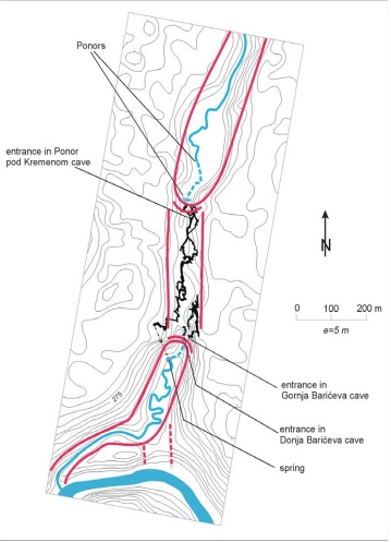
Slunjska uravnava je del kordunskega krasa. Ta se razteza v nad. viš. 300-350 m, od najdlje proti zahodu segajočega dela doline Une do sotočja Slunjčice in Korane. Dolga je 40 in povprečno 10 km široka. Večji del te uravnave, zgrajene iz jurskih in krednih karbonatnih kamnin, ima značilnosti kraškega reliefa s številnimi vrtačami. Na manjšem delu, ki ga gradijo paleozojski in terciarni klastični sedimenti in triasni dolomiti, je razvita površinska rečna mreža. Vodotoki, ki so na tej podlagi, na stiku s prepustnimi kamninami izginejo v podzemlje. Tekom geomorfološkega razvoja tega ozemlja se je površinsko odmakano površje zmanjševalo, sledovi tega pa so ostali v obliki slepih in suhih (fosilnih) dolin. Vodni tokovi so se s površja prestavili v podzemlje, kjer so izdolbli podzemeljske kanale, to je speleološke objekte. Delo analizira odnos med procesi, s pomočjo katerih so nastale (danes fosilne) doline in jamski rovi na treh primerih: 1. jamski sistem Matešićeva – Popovaćka jama, 2. Ponor pod Kremenom in Barićeve jame, 3. jamski sistem Varićakova – Panjkova jama.
The Slunj plateau is part of the shallow Kordun karst. It extends from the westernmost part of river Una towards the northwest to the confluence of the Slunjčica and Korana, at an average height of 300 - 350 m ofabove sea level. It is 40 km long, and averages about 10 km wide. A larger part of the plateau of Jurassic and Cretaceous carbonate rocks has characteristics of e karst relief with numerous dolines. On the smaller part of the Paleozoic and Tertiary clastic sediments and Triassic dolomites, a surface fluvial network has been developed. The water streams emerging on that basis regularly disappear underground on contact with permeable rocks. During geomorphological evolution of this terrain the area which is being drained on the surface was reduced, and the traces were left in the form of blind and dry (fossil) valleys. The water streams moved from the surface to underground where they formed the underground channels, i. e. speleological objects. This work analyses the correlation between the formation processes of (today fossil) valleys and cave channels on three examples: 1) Cave system Matešićeva - Popovačka cave, 2) Ponor pod Kremenom cave and Barićeve cave, 3) Cave system Varićakova - Panjkova cave.
Prenosi
Prenosi
Objavljeno
Kako citirati
Številka
Rubrike
Licenca
Avtorji jamčijo, da je delo njihova avtorska stvaritev, da v njem niso kršene avtorske pravice tretjih oseb ali kake druge pravice. V primeru zahtevkov tretjih oseb se avtorji zavezujejo, da bodo varovali interese založnika ter da bodo povrnili morebitno škodo.
Podrobneje v rubriki: Prispevki

