Contribution of Simple Hydrogeological Indicating Methods in Contamination-Impacted Environments
DOI:
https://doi.org/10.3986/ac.v36i2.194Povzetek
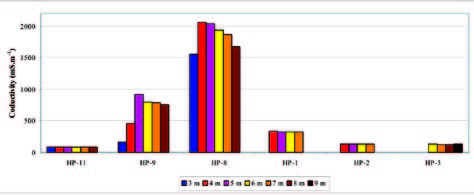
Under the project of Ministry of the environment of Slovak Republic a “real” impact of various contaminant sources on water was monitored and assessed during the period of 4 years. Various geological environments of The Western Carpathians were chosen as studying areas. The results of the project confirm that the influence of the contamination source is variable in space and time. An amount of objective and efficient information is necessary to fulfill the requirements for the water treatment. The possibility how to minimize the amount of expensive and intricate methods used by investigation was to connect them with hydrogeological indicating methods (HIM). The correlated relations distinguished between contaminant and physical characteristics of water allow using the obtained local information in larger area and repeating them in higher frequency. The economical benefit is relative to increasing demands on space and time. The base was built on the water conductivity and water temperature measurements set in field. The measured values which were processed basically allow obtaining indirect information about the contamination spreading. By correlation the values with water analyses for a monitoring site from specific studied locality and by added other information from field methods the results can be amplified. It is possible to substitute the intricate and expensive contaminant spreading mapping methods by HIM and monitor the dynamic changes of contamination influences in space and time with denser data net.
Prenosi

Prenosi
Objavljeno
Kako citirati
Številka
Rubrike
Licenca
Avtorji jamčijo, da je delo njihova avtorska stvaritev, da v njem niso kršene avtorske pravice tretjih oseb ali kake druge pravice. V primeru zahtevkov tretjih oseb se avtorji zavezujejo, da bodo varovali interese založnika ter da bodo povrnili morebitno škodo.
Podrobneje v rubriki: Prispevki


