
Analiza gostote vrtač z orodji GIS na kraški planoti Miljevci (Hrvaška)
DOI:
https://doi.org/10.3986/ac.v51i1.10465Ključne besede:
kras, gostota vrtač, geomorfometrija, GIS, HrvaškaPovzetek
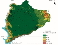
Analiza gostote vrtač in njihove prostorske razporeditve je ena od metod, ki se uporabljajo za morfostrukturno analizo kraškega reliefa. Avtorici predstavljata rezultate morfometričnih značilnosti, prostorske razporeditve vrtač in njihove povezanosti na kraški planoti Miljevci na podlagi digitalnega modela višin (DEM). Skupno je bilo na proučevanem območju kartiranih 286 vrtač. Uporabljena je bila analiza gostote vrtač. Rezultati kažejo, da je prostorska porazdelitev vrtač v obliki grozdov. Opredeljeni sta dve večji območji z gostoto 30 oziroma 34 vrtač/km2. Razporeditev teh vzdolž rečnih kanjonov bi lahko kazala na obstoj paleodrenažnega omrežja. Najmočnejša povezava med gostoto vrtač in topografijo je z naklonom in vertikalno razčlenjenostjo reliefa, pri čemer se število vrtač zmanjšuje z večanjem naklona pobočja in relativnega reliefa. Takšna porazdelitev potrjuje primernost kraških planot brez aktivne drenaže za nastanek vrtač.
Prenosi
Literatura
Artugyan, L., & Urdea, P. 2016: Using Digital Elevation Model DEM in karst terrain analysis. Study case : Anina mining area Banat Mountains Romania. -Carpathian Journal of Earth and Environmental Sciences, 111, 55 – 64.
Ballut C., Faivre, S. 2012: New data on the dolines of Velebit Mountain: An evaluation of their sedimentary archive potential in the reconstruction of landscape evolution.-Acta Carstologica, 41 (1), 59-74.
Bočić, N., Pahernik, M. I Bognar, A. 2010: Geomorfološka obilježja Slunjske zaravni.- Hrvatski geografski glasnik, 72(2), 5-26.
Bočić, N., Pahernik, M., & Mihevc, A. 2015. Geomorphological significance of the palaeodrainage network on a karst plateau: The Una–Korana plateau, Dinaric karst, Croatia.- Geomorphology, 247, 55–65.
Bognar, A. 1992: Inženjerskogeomorfološko kartiranje.- Acta Geographica Croatica, 27, 173-185.
Bognar, A. 2001: Geomorfološka regionalizacija Hrvatske.- Acta Geographica Croatica,
, 7-29.
Bognar, A., Faivre, S., Buzjak, S., Pahernik, M. I Bočić, N. 2012: Recent landform evolution in the Dinaric and Pannonian Region of Croatia, In: D. Lóczy, M. Stankoviansky i A. Kotarba(eds.) Recent Landform Evolution. Springer, Heidelberg-London-New York, 313-344.
Buzjak, N., Buzjak, S., Orešić, D. 2011: Florističke, mikroklimatske i geomorfološke značajke ponikve Japage na Žumberku.- Šumarski list, 1–2, 127-137.
Buzjak, N., Petković, A. I Faivre, S. 2013: Intenzitet prirasta i supkutane krške korozije u dolini rijeke Krke Hrvatska.- Hrvatski geografski glasnik, 75(2), 59-79.
CMHS 2021: Croatian Meteorological and Hydrological Service, Average monthly and annual air temperature °C and mean monthly and annual precipitation mm for the Šibenik and Drniš station, for the 1991 - 2020 period.
EU-DEM, 2018: Digital Elevation Model over Europe https://data.eox.at/eudem/, 06.02.2018.
Faivre, S. 1992: Analize gustoće ponikava na Sjevernom Velebitu i Senjskom bilu.- Senjski zbornik, 19, 13-24.
Faivre, S. 1994: Strukturno-geomorfološka analiza tipova dolinske mreže Sjevernog Velebita i Sinjskog bila.- Senjski zbornik, 21, 9-24.
Faivre, S. 1995: Neke temeljne strukturno-geomorfološke značajke sjevernog Velebita i Senjskog bila, In: Pepeonik, Z. (ed.) Zbornik radova 1. Hrvatskog geografskog kongresa, Hrvatsko geografsko društvo, Zagreb, 156-169.
Faivre, S. & Bocquet, J. 1999: Variation spatiale des contraintes tectoniques calculées a partir des dolines; Montagne de Velebit, Croatie.- Etudes de géographie physique. - CAGEP, 28, 83-88.
Faivre, S. & Reiffsteck, P. 1999: Spatial distribution of dolines as an indicator of recent deformations on the Velebit mountain range.- Geomorphologie: Relief, Processus, Environment, 2, 129-142.
Faivre, S. & Reiffsteck, P. 2002: From doline distribution to tectonic movements. Example of the Velebit mountain range, Croatia.- Acta carsologica, 31 (3), 139-154.
Faivre S., Pahernik M. 2007: Structural influences on the spatial distribution of dolines, Island of Brač, Croatia.- Zeitschrift für Geomorphol 51:487–503. https://doi.org/10.1127/0372-8854/2007/0051-0487
Ford, D., Williams, P. 2007: Karst Hydrogeology and Geomorphology. John Wiley and Sons Ltd.
Fouache, E., Ghilardi, M., Vouvalidis, K., Syrides, G., Styllas, M., Kunesch, S., and Stiros, S., 2008, Contribution on the Holocene reconstruction of Thessaloniki Coastal Plain, Greece: Journal of Coastal Research, 24 (5), 1161–1173. doi:10.2112/06-0786.1.
Friganović, M. 1961: Polja gornje Krke.- Acta Geographica Croatica, 3 (1)
Gabrovšek, F. & U. Stepišnik, 2011: On the formation of collapse dolines: A modelling perspective.- Geomorphology, 134, 23-31. https://doi.org/10.1016/j.geomorph.2011.06.007
Gallay, M., Kaňuk, J., Hofierka, J., Hochmuth, Z., Meneely, J. 2015: Mapping and geomorphometric analysis of 3-D cave surfaces: a case study of the Domica Cave, Slovakia, in: Jasiewicz, J., Zwoliński, Z., Mitasova, H., Hengl, T. Eds., Geomorphometry for Geosciences. Bogucki Wydawnictwo Naukowe, Adam Mickiewicz University in Poznań - Institute of Geoecology and Geoinformation, Poznań, Poland, pp. 69–73
Gams, I. 2000: Doline Morphogenetic Processes from Global and Local Viewpoints.- Acta Carsologica, 292. https://doi.org/10.3986/ac.v29i2.453
Grcić, I. 2019: Geomorfološke značajke miljevačkog dijela Sjevernodalmatinske krške zaravni (Geomorphological characteristics of the Miljevci plateau in the area of the Notrh Dalmatian karst plateau). Master thesis, University of Zadar
Hofierka, J., Gallay, M., Kaňuk, J., Šašak, J. 2017: Modelling Karst Landscape with Massive Airborne and Terrestrial Laser Scanning Data. Springer, Cham, pp. 141–154. https://doi.org/10.1007/978-3-319-45123-7_11
Ivanović, A., Sikirica, V., Marković, S., Sakač, K. 1977: Osnovna geološka karta 1:100 000 list Drniš, Institut za geološka istraživanja, Zagreb.
Kruk, B., Dedić, Ž., Kovačević-Galović, E. I Kruk, Lj. 2014: Osnove gospodarenja mineralnim sirovinama na području općine Promina u Šibensko-kninskoj županiji, Hrvatski geološki institut – Zavod za mineralne sirovine,
Lozić, S. 1996: Nagibi padina kopnenog dijela Republike Hrvatske.- Acta Geographica Croatica, 31, 41-50.
Mamužić, P. 1971: Osnovna geološka karta 1:100 000 list Šibenik, Institut za geološka istraživanja, Zagreb.
Marković, J., Bočić, N. I Pahernik, M. 2016: Prostorni raspored i gustoća ponikava jugoistočnog Velebita.- Geoadria 2181), 1-28.
Meng, X., Xiong, L., Yang, X., Yang, B., Tang, G. 2018: A terrain openness index for the extraction of karst Fenglin and Fengcong landform units from DEMs. J. Mt. Sci. 15, 752–764. https://doi.org/10.1007/s11629-017-4742-z
Mihevc A. 2007: The Age of Karst Relief in West Slovenia.- Acta Carsologica, 361. https://doi.org/10.3986/ac.v36i1.206
Mihevc A., & Mihevc R. 2021: Morphological characteristics and distribution of dolines in Slovenia, a study of a lidar-based doline map of Slovenia.- Acta Carsologica, 501. https://doi.org/10.3986/ac.v50i1.9462
Mihljević, D. 1994: Analysis of spatial characteristics in distribution of sink-holes, as an geomorphological indicator of recent deformations of geological structures. – Acta Geographica Croatica, 29, 29–36.
Moreno-Gómez, M., Liedl, R., Stefan, C., Moreno-Gómez, M., Liedl, R., Stefan, C. 2019: A New GIS-Based Model for Karst Dolines Mapping Using LiDAR; Application of a Multidepth Threshold Approach in the Yucatan Karst, Mexico.- Remote Sensing, 11, 1147. https://doi.org/10.3390/rs11101147
Öztürk, M. Z., Şener, M. F., Şener, M., & Şimşek, M. 2018: Structural controls on distribution of dolines on Mount Anamas Taurus Mountains, Turkey.- Geomorphology, 317, 107–116. https://doi.org/https://doi.org/10.1016/j.geomorph.2018.05.023
Pahernik, M. 2000: Prostorni raspored i gustoća ponikava SZ dijela Velike Kapele – rezultati računalne analize susjedstva.- Geoadria, 5, 105-120.
Pahernik, M. 2012: Spatial density of dolines in the Croatian Territory.- Hrvatski geografski glasnik, 74(2), 5-26.
Perica, D., Orešić, D. I Trajbar, S. 2005: Geomorfološka obilježja doline i porječja rijeke Krke s osvrtom na dio od Knina do Bilušića Buka.- Geoadria, 10(2), 131-156.
Peros, M., Collins, S., Agosta, A., Reinhardt, E., Pupo, FM. 2017: Multistage 8.2 kyr event revealed through high-resolution XRF core scanning of Cuban sinkhole sediments.- Geophys. Res. Lett., 44, 7374–7381.
Plan, L., Decker, K. 2006: Quantitative karst morphology of the Hochschwab plateau, Eastern Alps, Austria.- Zeitschrift für Geomorphol Suppl., 147, 29–54
Puceković. B. 2014: Ispitivanje točnosti Topografske karte u mjerilu 1:25 000 u izdanju Vojnogeografskog instituta u Beogradu.- Geodetski list, 1, 33-46.
Roglić, J. 1957: Zaravni na vapnencima.- Geografski glasnik, 19, 109-133
Sauro, U. 2013: Landforms of mountainous karst in the middle latitudes: reflections, trends and research problems.- Acta Carsologica 42:5–16. https://doi.org/10.3986/ac.v42i1.629
Sauro, U. 2016: Dolines and sinkholes: Aspects of evolution and problems of classification.- Acta Carsologica, 32, 41–52.
Sauro U, Francese R., Ferrarese F., Miola A., Mozzi P., Rondo GQ, Trombino L., Valentini G. 2009: Doline Fills - Case Study of the Faverghera Plateau Venetian Pre-Alps, Italy.- Acta Carsologica 38(1), 51-63.
Siart, C., Forbriger, M., Nowaczinski, E., Hecht, S., Höfle, B. 2013: Fusion of multi-resolution surface terrestrial laser scanning and subsurface geodata ERT, SRT for karst landform investigation and geomorphometric quantification.- Earth Surf. Process. Landforms 38, 1135–1147. https://doi.org/10.1002/esp.3394
Silva, O.L., Bezerra, F.H.R., Maia, R.P., Cazarin, C.L. 2017: Karst landforms revealed at various scales using LiDAR and UAV in semi-arid Brazil: Consideration on karstification processes and methodological constraints.- Geomorphology, 295, 611–630. https://doi.org/10.1016/J.GEOMORPH.2017.07.025
Šiljeg, A. 2013: Digitalni model reljefa u analizi geomorfometrijskih parametara – Primjer PP Vransko jezero, PhD thessis, Geografski odsjek PMF-a, Sveučilište u Zagrebu.
Šušteršič, F. 2016: Are “Collapse Dolines” Formed Only by Collapse?.- Acta Carsologica, 29(2). https://doi.org/10.3986/ac.v29i2.461
Telbisz, Т., Mari, L., Ćalić, J. 2007: Doline morphometry of Mt.Miroč using GIS methods.-Bulletin of the Serbian Geographical Society, 87(2), 21-30.
Telbisz, T., Dragušica, H. & Nagy, B., 2009: Doline Morphometric Analysis and Karst Morphology of Biokovo Mt Croatia Based on Field Observations and Digital Terrain Analysis.- Hrvatski Geografski Glasnik, 71(2), 5 – 22.
Telbisz, T., Mari, L. & Szabó, L., 2011. Geomorphological Characteristics of the Italian Side of Canin Massif Julian Alps Using Digital Terrain Analysis and Field Observations.- Acta Carsologica, 40/2, 255–266.
Tîrlă, L., Drăgușin, V., Bajo, P., Covaliov, S., Cruceru, N., Ersek, V., Hanganu, D., Hellstrom, J., Hoffmann, D., Mirea, I., Sava, T., Sava, G., & Şandric, I. 2020: Quaternary environmental evolution in the South Carpathians reconstructed from glaciokarst geomorphology and sedimentary archives.- Geomorphology, 354, 107038. https://doi.org/https://doi.org/10.1016/j.geomorph.2020.107038
Velić, I., Vlahović, I. 2009: Tumač geološke karte 1:300.000., Hrvatski geološki institut, Zagreb, p141.
Prenosi
Objavljeno
Kako citirati
Številka
Rubrike
Licenca

To delo je licencirano pod Creative Commons Priznanje avtorstva-Nekomercialno-Brez predelav 4.0 mednarodno licenco.
Avtorji jamčijo, da je delo njihova avtorska stvaritev, da v njem niso kršene avtorske pravice tretjih oseb ali kake druge pravice. V primeru zahtevkov tretjih oseb se avtorji zavezujejo, da bodo varovali interese založnika ter da bodo povrnili morebitno škodo.
Podrobneje v rubriki: Prispevki

