
Geographic Information Systems Analysis of Geologic Controls on the Distribution on Dolines in the Ozarks of South-Central Missouri, USA
DOI:
https://doi.org/10.3986/ac.v29i2.456Abstract
Geološki vzroki, ki pogojujejo razporeditev in razvoj vrtač na Salem planoti, Ozarki, južno-osrednji Missouri, ZDA, so bili statistično analizirani z uporabo GIS. Geološki vzroki predstavljajo litostratigrafijo, geološko strukturo, površje in globino do talne vode. Obravnavali so področje za točkovne podatke 2.613 vrtač na dveh 30’ × 60’ kartah s 30 m intervali. Izračunali so % pogostosti vrtač za pet litostratigrafskih enot, pri čemer so ugotovili, da je v Jefferson City dolomitu in Roubidoux formaciji največja gostota vrtač. Opravljena je bila analiza žariščne vsote sosedstva, da bi ugotovili, če ima razporeditev vrtač značilnost združevanja v skupine ali značilnost linearnosti, kar kaže na vpliv geološke strukture. Usmerjenost skupin vrtač na SZ se pojavlja vzdolž projekcije prelomne cone Bolivar-Mansfield v južno-osrednjem Missouriju. Večina vrtač na obravnavanem terenu se nahaja na območjih uravnav in na položnih pobočjih, kar je pogosteje kot na močno razčlenjenih področjih. Močna razpokanost v bližini regionalnih prelomnih con lahko pospeši razvoj vrtač na planoti. Razumevanje kraškega sistema je pomembno za boljše urejanje uporabe zemlje v Ozarkih, vključno z ohranjanjem naravnih virov, urejanjem talne vode in varovanjem okolja, še posebno ker raziskani teren vsebuje možne ekonomsko ugodne zaloge Pb in Zn.
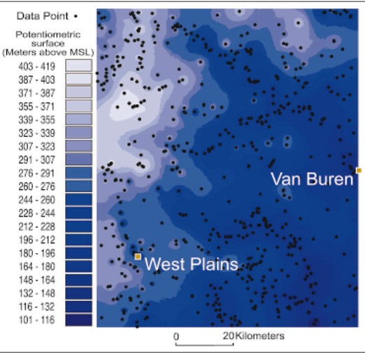
The geologic controls on the distribution and development of dolines in the Salem Plateau of the Ozark Plateaus Province, south-central Missouri, USA, was statistically analyzed by using a geographic information system. The controls include lithostratigraphy, geologic structure, slope, and depth to water table. Area and point data for 2,613 dolines in two 30’ x 60’ quadrangles were compiled on a 30-meter grid. The percent area of dolines was calculated for five lithostratigraphic units, and it was determined that the Jefferson City Dolomite and Roubidoux Formation have the highest density of dolines. A focal sum neighborhood analysis was performed to determine if the distribution of dolines had any clustering or linearity that may suggest structural control. A northwest alignment of doline clusters occurs along a projection of the Bolivar-Mansfield fault zone in south-central Missouri. Most dolines in the study area occur on the plateau areas and on gentle slopes rather than in the highly dissected areas. Intense fracturing near regional fault zones may enhance doline development on the plateau areas. An understanding of the karst system is important for better landuse management practices in the Ozarks, including conservation of natural resources, ground-water management, and environmental protection, especially because the study area includes potential economic lead and zinc mineralization.
Downloads
Downloads
Published
How to Cite
Issue
Section
License
Authors guarantee that the work is their own original creation and does not infringe any statutory or common-law copyright or any proprietary right of any third party. In case of claims by third parties, authors commit their self to defend the interests of the publisher, and shall cover any potential costs.
More in: Submission chapter

