
Visualisations of the Human Impacts on the Earth’s Surface
DOI:
https://doi.org/10.3986/ac.v36i2.192Abstract
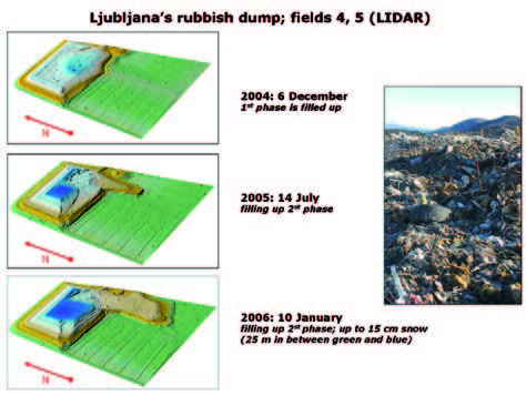
The objective is to discuss the human impacts to the changing of the landscape surface. The study surface is mainly karstic part of Slovenia. The primary data sources are digital elevation models (DEMs) as continuous surface data, supported with aerial photographs, satellite images and older topographic maps. This study is supplemented with textual information about of historical surfaces. Geomorphologically high quality DEM of Slovenia with 12.5 m resolution uncovered many human impacts to the terrain surface, which could not be perceived before using any classical surveying techniques. Particularly on the karstic areas, changes of the surface as a consequence of highway constructions and developing of the stone quarries are well seen. Additionally is involved a database of natural (ridges, valleys, peaks, sinkholes) and antropogenic features (stone and gravel quarries, standing waters, different types of roads and railways) on the current terrain surface. Even more surface changes were found on the LIDAR-based DEM of 1 m resolution. Some human impacts to the surface changes from prehistory until today were analysed with many visual techniques and confirmed with objective numerical methods. The results show that is the human impact on the Earth’s surface important factor that grows exponentially with time.
Downloads
Downloads
Published
How to Cite
Issue
Section
License
Authors guarantee that the work is their own original creation and does not infringe any statutory or common-law copyright or any proprietary right of any third party. In case of claims by third parties, authors commit their self to defend the interests of the publisher, and shall cover any potential costs.
More in: Submission chapter

