
Constraints on the Geological History of the Karst System in Southern Missouri, U.S.A. Provided by Radiogenic, Cosmogenic and Physical/Chemical Characteristics of Doline Fill
DOI:
https://doi.org/10.3986/ac.v33i2.300Abstract
Območje Ozarkov v južnem Missouriju gradijo predvsem karbonatne, morske, platformne kamnine paleozojske starosti. Teren, ki vsebuje obširen kras, predstavlja kopno že od poznega Paleozojka. Da bi bolje razumeli geološko zgodovino tega kraškega sistema, smo raziskali stratigrafske podatke ohranjene v zapolnitvi velike vrtače pri največjem izviru v okolici. Vzorci zapolnitve iz naravnih izdankov in iz vrtine so bili analizirani s termoluminiscenco (TL) in 10Be kozmogeno metodo. Fizikalno-kemijske značilnosti zapolnitve so bile določene vizualno, z rentgensko metodo in merjenjem velikosti delcev. Podatki vrtine kažejo, da je debelina alohtonega materiala, ki zapolnjuje vrtačo 36,3 m. Ta material prekriva podorne bloke in sedimente debeline vsaj 15,6 m. Glede na teksturo, strukturo in barvo delimo material, ki zapolnjuje vrtačo na 7 con. Analize 10Be koncentracij kažejo, da material za celotni stolpec zapolnitve izvira iz rezidualnega materiala iz srednjega (Illinoian) in zgornjega Pleistocena (Wisconsian). Rentgenske analize glin kažejo, da zapolnitev vrtače vsebuje enake količine kaolinita in illita, kar je skladno z zemeljskim preperevanjem.
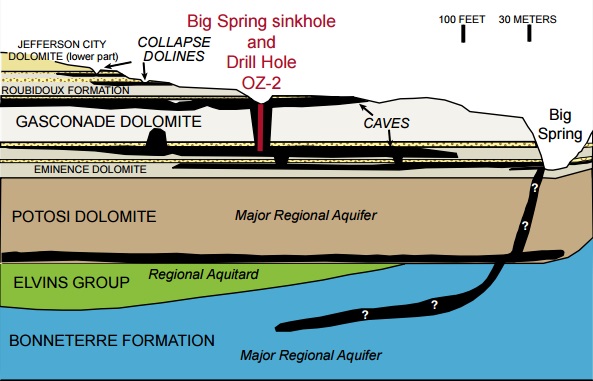
The Ozark Plateaus region of southern Missouri is underlain by dominantly carbonate marine platform rocks of Paleozoic age. The region has been sub-aerially exposed since the late Paleozoic and is characterized by extensive karst. To better understand the geologic history of this regional karst system, we examined the stratigraphic record preserved in the fill of a large doline near the largest spring in the region. Samples of fill from natural exposures and drill core were analyzed using thermoluminescence (TL) and 10Be cosmogenic techniques, and the physical/chemical characteristics of the fill material were determined by visual inspection, X-ray analyses, and grain-size measurements. Drill-hole data indicate that the allochthonous doline fill is 36.3 m thick and rests on at least 15.6 m of cave breakdown and sediment. The doline fill is divisible into 7 zones. Analysis of 10Be concentrations suggest that the entire doline fill was derived from local residuum during the middle (Illinoian) to late Pleistocene (Wisconsinan). X-ray diffraction analyses of clays throughout the doline fill indicate that they consist of nearly equal amounts of kaolinite and illite, consistent with terrestrial weathering.
Downloads
Downloads
Published
How to Cite
Issue
Section
License
Authors guarantee that the work is their own original creation and does not infringe any statutory or common-law copyright or any proprietary right of any third party. In case of claims by third parties, authors commit their self to defend the interests of the publisher, and shall cover any potential costs.
More in: Submission chapter

