
Vulnerability Mapping in the Recharge Area of the Korentan Spring, Slovenia
DOI:
https://doi.org/10.3986/ac.v33i2.296Abstract
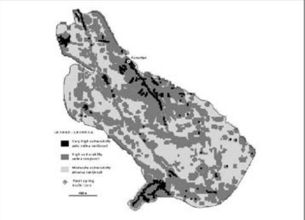
Zaradi dobro razvitega sistema kraških kanalov in razpok, ki omogoča hiter tok podzemne vode in tudi hiter prenos škodljivih snovi, so kraški vodonosniki zelo ranljivi za onesnaženje. Osnovo za njihovo ustrezno varovanje predstavljajo karte ranljivosti. Za izdelavo teh kart so bile razvite različne metode, pri oceni ranljivosti zaledja izvira Korentan pri Postojni pa smo uporabili metodo EPIK, ki je bila že večkrat uspešno preizkušena na krasu in stopnjo ranljivosti določa v odvisnosti od štirih parametrov: razvitosti epikrasa, učinkovitosti varovalnega pokrova, pogojev infiltracije in razvitosti kraške mreže. Za oceno posameznih parametrov smo uporabili različne raziskovalne metode kot so podrobno strukturno-litološko in geomorfološko kartiranje ter vzporedna analiza hidravličnih in fizikalno-kemičnih odzivov izvira na padavinske dogodke. Izdelana karta ranljivosti opredeljuje območja zelo velike, velike in zmerne ranljivosti znotraj zaledja izvira Korentana in jo lahko uporabimo kot osnovo za omejitev varstvenih pasov.
Karst aquifers are very vulnerable to pollution due to well developed system of karst channels and fissures which enable fast groundwater flow and also fast transport of pollutants. An expert bases for their protection are vulnerability maps. Different methods for the construction of these maps were developed, and to assess the vulnerability of the recharge area of the Korentan spring near Postojna the EPIK method was used. In this method, which was many times successfully tested on karst, the degree of vulnerabilty is defined on the basis of four parameters: developement of the epikarst, effectiveness of the protective cover, infiltration conditions, and development of the karst network. For the assessment of individual parameters different research methods were used, such as detailed structural-lithological and geomorphological mapping, and combined analysis of hydraulic and physico-chemical responses of the spring to recharge events. Final result is the vulnerability map, which defines the areas of very high, high and moderate vulnerability within the recharge area of the Korentan spring and can be used to set up the protection zones.
Downloads
Downloads
Published
How to Cite
Issue
Section
License
Authors guarantee that the work is their own original creation and does not infringe any statutory or common-law copyright or any proprietary right of any third party. In case of claims by third parties, authors commit their self to defend the interests of the publisher, and shall cover any potential costs.
More in: Submission chapter

