
Geological Structure of the Divača Area and its Influence on Kačna Cave Speleogenesis and Hydrogeology
DOI:
https://doi.org/10.3986/ac.v44i2.1958Abstract
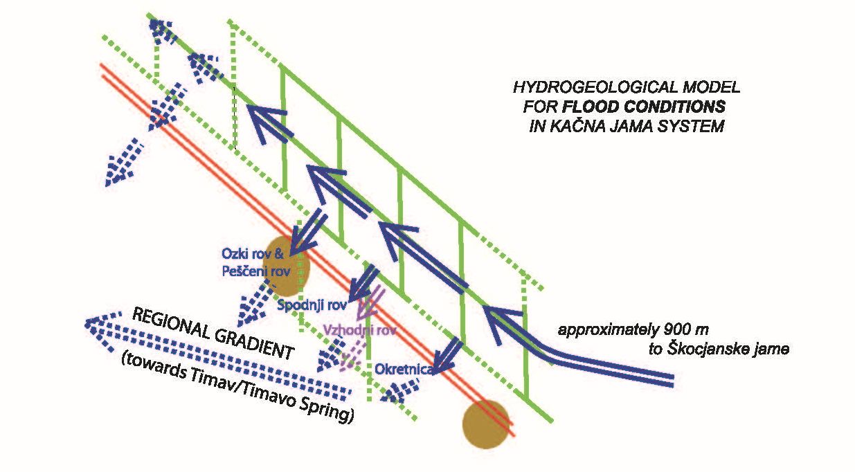
Caves develop along sedimentary and tectonic discontinuities within soluble rock mass. In the Slovene Classical Kras (Karst), the primary lithologies are limestone and dolomite. Previous research of cave systems in SW Slovenia indicated a clear relationship between cave channel directions with local structural elements, which is also documented in the mapped area. Kačna jama is the longest cave of the Kras Plateau and represents an important part of the underground flow of the Reka River. For structural mapping, we applied a method adopted for the surface of karstic terrains. We documented three NW−SE oriented faults and additionally an equally oriented fracture zone. These structures are parallel to the regional Divača Fault, which was detected in the NW edge of the mapped area. Between them, the cross-oriented fracture zones run, and occasionally bend, towards N−S orientation. The described structure is explained using a complex, divergent-convergent, dextral strike-slip fault-wedge. Among the detected structures, we focus on the Risnik Fault along which the Risnik and Bukovnik collapse dolines are developed, whereas in the Kačnja jama the same fault is manifested by several rock-fall accumulations. During dry-weather conditions groundwater is drained through the fault in the terminal sump at the end of the Ozki rov channel. Whereas during floods, the same fault acts as a hydrogeological barrier, because the previously mentioned terminal sump is no longer capable of transmitting sufficient quantities of groundwater, which in such conditions flow along the fault through a well-developed system of channels in the NW direction. We propose that the Risnik Fault acts as a deflector fault.
Geološka Struktura na območju Divače in njen vpliv na spelogenezo ter hidrogeologijo Kačne jame
Jame se razvijajo vzdolž nezveznosti, sedimentarnega ali tektonskega izvora v zaporedju topnih kamnin. Na Klasičnem Krasu slednje predstavljata apnenec in dolomit. Predhodne raziskave kraških terenov jugozahodne Slovenije so pokazale jasno povezavo med smerjo jamskih kanalov in lokalnih strukturih elementov, kar se je pokazalo tudi na prikazanem območju kartiranja. Kačna jama je najdaljša jama Klasičnega Krasa in predstavlja pomemben del podzemnega toka reke Reke. S strukturnim kartiranjem površine nad jamo, ki je prilagojeno kraškim ozemljem, smo ugotovili potek treh SZ−JV prelomov in ene vmesne razpoklinske cone v enaki smeri. Te strukture so vzporedne regionalnemu Divaškemu prelomu, ki smo ga zaznali na skrajnem SV delu raziskanega območja. Med njimi potekajo prečno usmerjene razpoklinske cone, ki so deloma povite do smeri S−J. Opisano strukturo razlagamo s kompleksnim divergentno-konvergentnim desno-zmičnim prelomnim klinom. Posebej obravnavamo Risniški prelom, ob katerem sta razviti udornici Risnik in Bukovnik, ter nekaj večjih podorov v jami. V odtočni sifon na koncu Ozkega rova nizke vode odtekajo skozi Risniški prelom v smeri regionalnega gradienta. Medtem za visoke vode isti prelom predstavlja hidrogeološko zaporo, saj prej omenjeni odtočni sifon ne zmore več prevajati zadostnih količin podzemne vode in ta odteka vzdolž preloma po dobro razvitem sistemu kanalov v NW smeri. Menimo, da ima Risniški prelom vlogo zapornega preloma.
Downloads
Downloads
Published
How to Cite
Issue
Section
License
Authors guarantee that the work is their own original creation and does not infringe any statutory or common-law copyright or any proprietary right of any third party. In case of claims by third parties, authors commit their self to defend the interests of the publisher, and shall cover any potential costs.
More in: Submission chapter

