
Cave-PY a QGIS plugin to identify cave levels from geospatially referenced cave surveys
DOI:
https://doi.org/10.3986/ac.v54i1.14294Keywords:
Cave levels, qgis, cave geometry, geospatial analyis caves, Qgis pluginAbstract
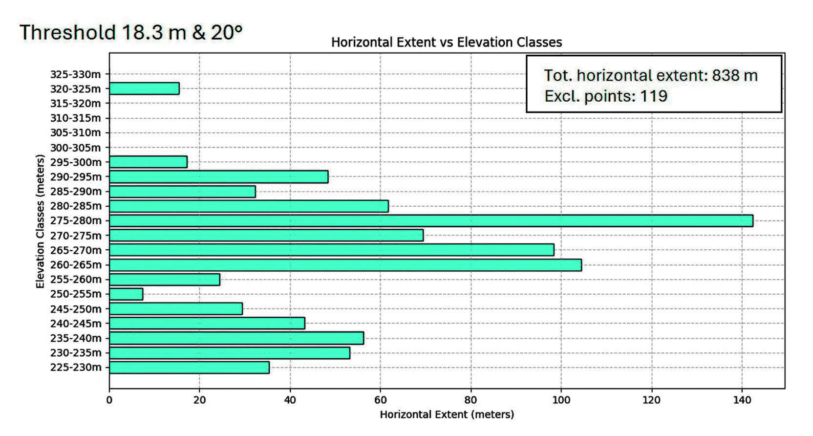
Cave-PY is a QGIS plugin developed to identify and analyze cave levels from geospatially referenced cave survey data. Cave levels, cave tiers, or cave stories are subhorizontal passages in karst systems that develop at different elevations due to base level changes or litho-structural factors. This algorithm processes point cloud data by calculating horizontal distances between survey points based on user-defined slope thresholds and proximity radius parameters. The horizontal extent is grouped into elevation classes to identify potential cave levels. We use Stortuvhola cave located in Northern Norway, a multi-level system, where we demonstrate the plugin's ability to effectively reveal cave levels from both survey station data and complete cave survey datasets. The sensitivity tests we performed highlight the importance of appropriate parameter selection based on survey characteristics. While Cave-PY offers an efficient method for the initial extraction of cave levels, it is important that the results are validated through morphological criteria and cave survey information for correct interpretation. We believe this tool addresses a gap in the existing methodology for geospatial analysis of caves.
Downloads
References
Audra, P., and Palmer, A. N., 2011, The pattern of caves: controls of epigenic speleogenesis: Géomorphologie : relief, processus, environnement, v. 17, no. 4, p. 359-378.
Audra, P., and Palmer, A. N., 2015, Research frontiers in speleogenesis. Dominant processes, hydrogeological conditions and resulting cave patterns: Acta Carsologica, v. 44, no. 3.
Ballesteros, D., Jimenez-Sanchez, M., Giralt, S., Garcia-Sansegundo, J., and Melendez-Asensio, M., 2015, A multi-method approach for speleogenetic research on alpine karst caves. Torca La Texa shaft, Picos de Europa (Spain): Geomorphology, v. 247, p. 35-54.
Budaj, M., and Mudrák, S., Therion: Digital cave maps, in Proceedings 4th European Speleological Congress2008, Volume 6.
Calvet, M., Gunnell, Y., Braucher, R., Hez, G., Bourlès, D., Guillou, V., and Delmas, M., 2015, Cave levels as proxies for measuring post-orogenic uplift: Evidence from cosmogenic dating of alluvium-filled caves in the French Pyrenees: Geomorphology, v. 246, p. 617-633.
Calvet, M., Gunnell, Y., Delmas, M., Braucher, R., Jaillet, S., Häuselmann, P., Delunel, R., Sorriaux, P., Valla, P. G., and Audra, P., 2024, Valley incision chronologies from alluvium-filled cave systems: Earth-Science Reviews, v. 258.
De Waele, J., and Gutiérrez, F., 2022, Karst Hydrogeology, Geomorphology and Caves.
Filipponi, M., Jeannin, P. Y., and Tacher, L., 2009, Evidence of inception horizons in karst conduit networks: Geomorphology, v. 106, no. 1-2, p. 86-99.
Granger, D. E., Fabel, D., and Palmer, A. N., 2001, Pliocene−Pleistocene incision of the Green River, Kentucky, determined from radioactive decay of cosmogenic 26Al and 10Be in Mammoth Cave sediments: Geological Society of America Bulletin, v. 113, no. 7, p. 825-836.
Heeb, B., 2010, A general calibration algorithm for 3-axis compass/clinometer devices: Cave Radio and Electronics Group Journal, v. 73.
Lønøy, B., Pennos, C., Tveranger, J., Fikos, I., Vargemezis, G., and Lauritzen, S.-E., 2021, Delimiting morphological and volumetric elements of cave surveys as analogues for paleokarst reservoir modelling – A case study from the Maaras cave system, northern Greece: Marine and Petroleum Geology, v. 129.
Lønøy, B., Tveranger, J., Pennos, C., Whitaker, F., and Lauritzen, S.-E., 2020, Geocellular rendering of cave surveys in paleokarst reservoir models: Marine and Petroleum Geology, v. 122.
Lowe, D., 2000, Radial Basis Function Networks and Statistics, in Kay, J. W., and Titterington, D. M., eds., Statistics and Neural Networks: Advances at the Interface, Oxford University Press, p. 0.
Lowe, D. J., and Gunn, J., 1997, Carbonate speleogenesis: an inception horizon hypothesis, Slovenska akademija znanosti in umetnosti.
Nehme, C., Jaillet, S., Voisin, C., Hellstrom, J., Gerard-Adjizian, J., and Delannoy, J. J., 2016, Control of cave levels in Kanaan, Kassarat and Jeita karst systems (Central Mount Lebanon, Lebanon): Zeitschrift Fur Geomorphologie, v. 60, no. 2, p. 95-117.
Pennos, C., Lauritzen, S. E., Pechlivanidou, S., and Sotiriadis, Y., 2016, Geomorphic constrains on the evolution of the Aggitis river basin, northern Greece (a preliminary report): Bulletin of the Geological Society of Greece.
Piccini, L., 2011, Recent developments on morphometric analysis of karst caves: Acta Carsologica, v. 40, no. 1.
Piccini, L., and Iandelli, N., 2010, Tectonic uplift, sea level changes and Plio‐Pleistocene evolution of a coastal karst system: the Mount Saint Paul (Palawan, Philippines): Earth Surface Processes and Landforms, v. 36, no. 5, p. 594-609.
Plan, L., Filipponi, M., Behm, M., Seebacher, R., and Jeutter, P., 2009, Constraints on alpine speleogenesis from cave morphology - A case study from the eastern Totes Gebirge (Northern Calcareous Alps, Austria): Geomorphology, v. 106, no. 1-2, p. 118-129.
Rummler, L., Plan, L., and Hauser, X., 2024, Cave Levels in the Totes Gebirge (Eastern Alps): Austrian Journal of Earth Sciences, v. 117, no. 1, p. 163-175.
Strasser, M., Strasser, A., Pelz, K., and Seyfried, H., 2009, A mid Miocene to early Pleistocene multi-level cave as a gauge for tectonic uplift of the Swabian Alb (Southwest Germany): Geomorphology, v. 106, no. 1–2, p. 130-141.
Szczygieł, J., 2015, Cave development in an uplifting fold-and-thrust belt: case study of the Tatra Mountains, Poland: International Journal of Speleology, v. 44, no. 3, p. 341-359.
Szczygieł, J., Hercman, H., Hoke, G., Gąsiorowski, M., Błaszczyk, M., and Sobczyk, A., 2020, No valley deepening of the Tatra Mountains (Western Carpathians) during the past 300 ka: Geology, v. 48, no. 10, p. 1006-1011.
Thorvik., M., 2019, Grotters strukturelle arkitektur - studium av Aspfjordgrotten, Fauske, Nordland [Master Thesis: University of Bergen.
Downloads
Published
How to Cite
Issue
Section
License

This work is licensed under a Creative Commons Attribution 4.0 International License.
Authors guarantee that the work is their own original creation and does not infringe any statutory or common-law copyright or any proprietary right of any third party. In case of claims by third parties, authors commit their self to defend the interests of the publisher, and shall cover any potential costs.
More in: Submission chapter

