
The Permian gypsum karst belt along the southern margin of the Harz-mountains (Germany), tectonic control of regional geology and karst hydrogeology
DOI:
https://doi.org/10.3986/ac.v49i1.8965Keywords:
Harz Mountains, South-Harz belt, tectonics, Zechstein, Upper Permian, regional geology, karst hydrogeologyAbstract
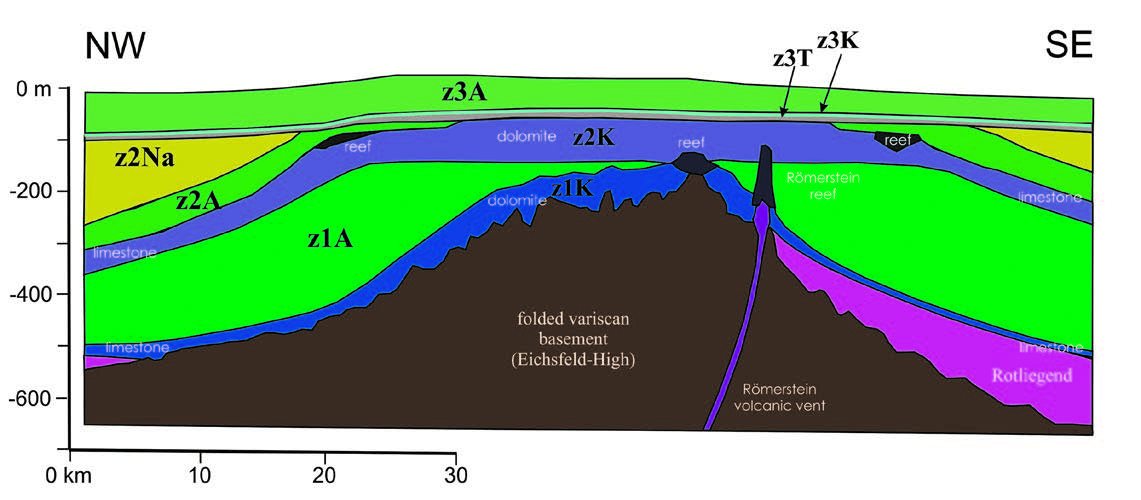
The Harz Mountains in Germany are a south-tilting block of variscan-folded Devonian and Carboniferous rocks thrust over Mesozoic sediment along its northern border. Along the South Harz the overlying, unfolded upper-most Carboniferous, Permian and Buntsandstein (lower Triassic) series are exposed in a wide belt. They include a thick series of Upper Permian (“Zechstein”) evaporitic rocks, dipping with about 10° S to SW, representing a nearly continuous sulfate and carbonate karst area about 90 km long, covering 338 km². In his dissertation, the first author compiled a new geological map for the Zechstein at a scale of 1:10,000 and deduced a tectonic model to advance our understanding of the karstic features. Karstification determines the morphology of the South Harz including over 180 registered caves, thousands of sinkholes, uvalas, sinking creeks and large karstic springs. Specifically, lines of sinkholes appear to follow faults. By detailed mapping of the three lowermost Zechstein cycles, a dense matrix of faults is revealed. 85° to 125° striking faults reoccur every few 500 m, formed during the Harz-lifting compressional phase during the Upper Cretaceous. Many of these faults are reverse with a Nward thrust. This leads to repetitive exposure of the strata, causing the broadening of the Zechstein outcrop beyond what would be caused by the dip of the series alone. In other areas, horstand graben-structures are present, resulting in kilometer-long Lower Buntsandstein ridges. Below ground, the groundwater flowing southward along the dip is diverted into the direction of diachronicalthe strike, thus causing strike-parallel depressions, valleys and sinkhole rows. In the final extension phase, faults striking 150° to 180° have caused graben-structures, allowing groundwater and surface rivers to flow southward, breaking through the escarpment of the overlying Lower Buntsandstein. Therefore, the tectonic structure of the South Harz determines its hydrology and the karst features apparent at the surface. The tectonic situation of the three largest karstic springs, the Salza Spring at Förste, the Rhume Spring, and the Salza Spring at Nordhausen is discussed along with more shallow karstic settings of the Hainholz/Beierstein, the Trogstein and the area of Hainrode.
Downloads
Downloads
Published
How to Cite
Issue
Section
License

This work is licensed under a Creative Commons Attribution-NonCommercial-NoDerivatives 4.0 International License.
Authors guarantee that the work is their own original creation and does not infringe any statutory or common-law copyright or any proprietary right of any third party. In case of claims by third parties, authors commit their self to defend the interests of the publisher, and shall cover any potential costs.
More in: Submission chapter

