
Glaciokarst landforms in the Siera de los Grajos, Babia and Luna natural park (Cantabrian Mountains, NW Spain)
DOI:
https://doi.org/10.3986/ac.v46i2-3.5001Keywords:
glaciokarst landforms, glacial geomorphology, karst geomorphology, geomorphological mapping, Cantabrian MountainsAbstract
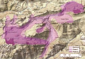
Landforms resulting from the interaction between paleo-glaciers and karst are studied by using the Sierra de los Grajos (Cantabrian Mountains) as a model. This area contains glacial landforms that have not interested geomorphologists due to their low altitude (Peña Castillo is about 1857 m a.s.l.), the absence of glacial cirques and the scarcity of large moraines. However, the prevalence of groundwater flow and chemical dissolution has favoured the preservation of glacial landforms. Lateral and frontal moraines show three main glacial stages and other minor glacier stabilization phases, with the paleo-ELA oscillating between 1650 and 1760 m. Moraines are combined with depressions and sinks resulting from subglacial karstic drainage. This convergence of forms and processes is an exception in the Cantabrian Mountains, where postglacial erosion has usually eroded the frontal moraines and the proglacial sediments. In the case of the Sierra de los Grajos, despite the underground drainage and preservation of many glacial deposits on karstic landforms, an outwash-plain was formed. These proglacial sediments and others from non-karstified areas filled the depressions of the preglacial terrain located at their edges. The main glaciokarstic landforms have been mapped and a sedimentological analysis of the outwash plain was made in order to reconstruct the glacial dynamics of this area.
Key words: glaciokarst landforms, glacial geomorphology, karst geomorphology, geomorphological mapping, Cantabrian Mountains.
Glaciokraški relief na območju Sierra de los Grajos v parku Babia in luna (Kantabrijsko gorovje, SZ Španija)
Na območju Sierra de los Grajos (Kantabrijsko gorovje) smo raziskovali relief, ki je v preteklosti nastal z medsebojnim vplivanjem kraških in ledeniških procesov. Zaradi nizke nadmorske višine (Peña Castillo je le 1857 m nad morjem) ter odsotnosti velikih moren in krnic to območje geomorfologov do sedaj ni posebej zanimalo. Prav kraški procesi in z njimi povezano podzemno odtekanje so tu omogočili ohranitev ledeniških oblik. Bočne in čelne morene kažejo na tri glavne faze poledenitev in več manjših faz stabilizacije ledenikov z ravnovesno mejo (ELA) med 1650 in 1760 m.n.m. Morene so pogosto vezane na kraške globeli. Glaciokraške pojave najdemo le na tem območju Kantabrijskega gorovja, kjer je sicer poledeniška erozija odstranila čelne morene in proglacialne sedimente. Kljub podzemnemu odtoku in ohranitvi številnih ledeniških sedimentov na kraškem reliefu se je na Sierra de los Grajos oblikoval predledeniški vršaj (sander). Proglacialni sedimenti in sedimenti iz nekraških območij so zapolnili globeli v predledeniškem kraškem terenu. Kartiranje glaciokraških reliefnih in analiza sedimentov predledeniških vršajev sta nam omogočila rekonstrukcijo dinamike ledenika na obravnavanem območju.
Ključne besede: glaciokraške reliefne oblike, ledeniška geomorfologija, kraška geomorfologija, geomorfološko kartiranje, Kantabrijsko gorovje, Španija.
Downloads
Downloads
Published
How to Cite
Issue
Section
License
Authors guarantee that the work is their own original creation and does not infringe any statutory or common-law copyright or any proprietary right of any third party. In case of claims by third parties, authors commit their self to defend the interests of the publisher, and shall cover any potential costs.
More in: Submission chapter

