
The study of karstic aquifers by geodetic measurements in Bus de la Genziana station – Cansiglio plateau (Northeastern Italy)
DOI:
https://doi.org/10.3986/ac.v40i1.35Abstract
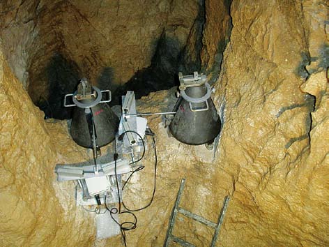
We propose an interdisciplinary study of karstic aquifers using tiltmeters and GPS observations. The study region is located in northeastern Italy, in the seismic area of the Cansiglio Plateau. The Zöllner type Marussi tiltmeters are installed in a natural cavity (Bus de la Genziana) that is part of an interesting karstic area of particular hydrogeologic importance. The Livenza river forms from a number of springs at the foothills of the karstic massif and flows throughthe Friuli-Veneto plain into the Adriatic Sea. Comparing the tiltmeter signal recorded at the Genziana station withthe local pluviometrical series and the hydrometric series of the Livenza river, a clear correlation is recognized. Moreover, the data of a permanent GPS station located on the southern slopes of the Cansiglio Massif (CANV) show also a clear correspondence withthe water runoff. Here we present the hydrologic induced deformations as observed by tiltmeter and GPS. After heavy rain events we record rapid deformations bothby tiltmeters and GPS corresponding to the rainfall duration. In the following days a slow geodetic motion recovers the accumulated deformation witha distinctive pattern bothin tilt and GPS data, whichcorrelates withthe runoff of the karstic aquifer. The purpose of this researchis to open a new multidisciplinary frontier between geodetic and karstic systems studies to improve the knowledge of the underground fluid flow circulation in karstic areas. Furthermore a better characterization of the hydrologic effects on GPS and tilt observations will have the benefit that these signals can be corrected when the focus of the study is to recover the tectonic deformation.
Downloads
Downloads
Published
How to Cite
Issue
Section
License
Authors guarantee that the work is their own original creation and does not infringe any statutory or common-law copyright or any proprietary right of any third party. In case of claims by third parties, authors commit their self to defend the interests of the publisher, and shall cover any potential costs.
More in: Submission chapter

