
High-Accuracy Graphic Representation of Underground Karst Features and Formations During Cave Mapping
DOI:
https://doi.org/10.3986/ac.v33i1.332Abstract
Prispevek predstavlja poskus razvoja nove metode kartiranja jam. Metoda nadgrajuje klasično kartiranje z večjo količino in natančnostjo podatkov, pri čemer predvideva, da na jamski načrt vnesemo vse kar v jami vidimo: korozijske oblike, vodna telesa, podorne bloke, razpoke v jamskih stenah, umetne posege v jamo itd. Metoda uporablja tradicionalen nabor simbolov, pri čemer ločljivost ustreza ločljivosti inženirskih načrtov. Na karti so natančno predstavljene lokacija, oblika in dimenzija jamskih oblik; npr. vsi stalagmiti z premerom nad 10 cm in vsi bloki z linearno dimenzijo nad 0.5 m so posamično prikazani. Prispevek obravnava najpomembnejše vidike te metode, predstavi različne faze meritev in kartiranja, način risanja in kartografske simbole.
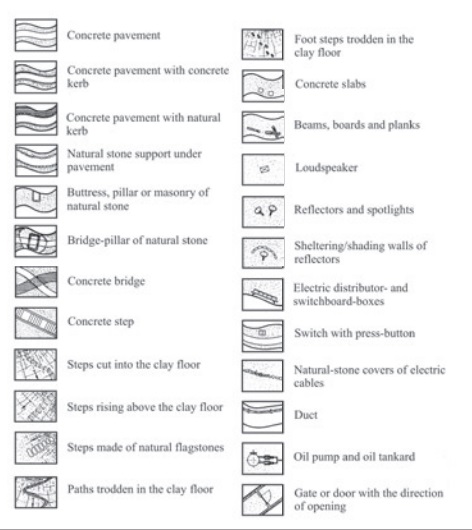
We attempt to develop a new method of cave mapping, which would be superior in terms of the amount and quality of the documented information, relative to the “standard” methods of cave survey. The method envisages that everything that can be seen in the cave which is being surveyed, e.g., corrosional features, cave formations, water bodies, fallen rock blocks, fractures in cave walls, artifi cial (engineering) structures, etc., must be represented on the map. The method employs the traditional system of map symbols; the accuracy of the produced map, however, approaches the accuracy of the engineering survey maps. The maps accurately render positions, shapes and dimensions of cave features: for example all stalagmites with diameters greater than ca. 10 cm, and all rock blocks with linear sizes exceeding 0.5 m are shown on the maps individually. In the report we will elaborate on the most important aspects of this mapping method, including stages of survey and mapping, system of drawing, map symbols.
Downloads
Downloads
Published
How to Cite
Issue
Section
License
Authors guarantee that the work is their own original creation and does not infringe any statutory or common-law copyright or any proprietary right of any third party. In case of claims by third parties, authors commit their self to defend the interests of the publisher, and shall cover any potential costs.
More in: Submission chapter

