Hydrogeological research as a basis for the preparation of the plan of monitoring groundwater contamination: A Case Study of the Stara Vas Landfill near Postojna (SW Slovenia)
DOI:
https://doi.org/10.3986/ac.v34i2.273Abstract
V Sloveniji je na krasu trenutno aktivnih devet odlagališč komunalnih odpadkov, med drugimi tudi Stara vas pri Postojni. Ker je za kraška območja značilna močna razpokanost kamninske osnove in zelo dobra prepustnosti, izcedne vode z odlagališč še posebej ogrožajo podzemno vodo. Sposobnost naravne filtracije je v krasu majhna,obseg možnega negativnega vpliva pa zelo velik. Sedaj veljavna zakonodaja predpisuje obratovalni monitoring, del katerega je tudi merjenje parametrov onesnaženosti podzemnih vod z nevarnimi snovmi, če so v vplivnem območju odlagališča. Temelj za izdelavo načrta monitoringa so ustrezne hidrogeološke raziskave. Za primer Stare vasi smo poleg osnovnih geoloških in hidrogeoloških podatkov uporabili še rezultate sledilnih poskusov, ožje območje odlagališča pa smo podrobno tektonsko-litološko kartirali v merilu 1:5000. Na osnovi ugotovljenih značilnosti pretakanja vode v podzemlju in v skladu s predpisi smo določili 3 točke monitoringa znotraj (izvira Malenščica in Vipava, jama Fužina) in eno izven vplivnega območja odlagališča (Matijeva jama) ter določili način spremljanja kakovosti vode in izdatnosti
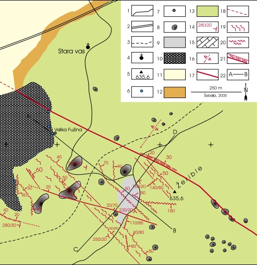
For the present 9 land fills on karst are still active in Slovenia, among them also the Stara vas land fill near Postojna. As strong fissuration of the rock base and very good permeability istypical for karst areas, the waste waters from the landfills particularly endanger the groundwater.The capacity of natural filtration in karst is very low and the dimension of possible negative impact is very high. The actual legislation regulates the performance of operational monitoring, a part of which is also the measurement of parameters of contamination of groundwater by hazardous substances, if they are in the area of influence of the landfill. Preparation of the monitoring plan is based on adequate hydrogeological researches. Besides basic geological and hydrogeological data also the results of tracer tests were used in the case study of the Stara vas landfill.Additionally, the detailed tectonic-lithological mapping in the scale 1:5000 was performed in the narrow area of the landfill.Based on defined characteristics of underground water flow and in accordance with the regulations 3 monitoring points inside (Malenščica and Vipava springs, Fužina cave) and one point outside the area of influence of the landfill (Matijeva jama cave) were selected. The monitoring plan for the observation of water quality and capacity was suggested.
Downloads

Downloads
Published
How to Cite
Issue
Section
License
Authors guarantee that the work is their own original creation and does not infringe any statutory or common-law copyright or any proprietary right of any third party. In case of claims by third parties, authors commit their self to defend the interests of the publisher, and shall cover any potential costs.
More in: Submission chapter


