
The Morphological Research of the Basalt and Loess Covered Plateaus in the Bakony Mts. (Transdanubian Middle Mts. – Hungary)
DOI:
https://doi.org/10.3986/ac.v34i2.266Abstract
V članku poročamo o morfoloških raziskavah na puhlični planoti Tési in z bazaltom prekritim kraškim območjem v okolici gore Kab na južnem delu gorovja Bakony. Skoraj 600 m visoka gora Kab, prekrita z bazaltom, izstopa iz hribovitega predela južnega dela gorovja Bakony. Površina gore, ki meri kakih 35-40 km², je prekrita z različno debelim bazaltom. Na bazaltnem površju so razvite psevdokraške oblike (depresije), ki so posledica zakrasevanja apnenca pod bazaltom. Z združevanjem glede na morfologijo in hitrost razvoja ter študijem korelacije genetskih značilnosti nastalih združb, smo izluščili nove kraške procese, kjer smo lahko depresije različnih oblik intepretirali kot različne stopnje iste razvojne poti. Mezozojske kamnine planote Tési le redko pogledajo na površje izpod pokrova puhlice. Blizu vrhov so nastajale udorne in ponorne vrtače z zelo omejenim območjem napajanja. Raziskave procesov, oblik in pojavnosti pokritega krasa gore Bakony so pokazale, da je nastanek recentnih jaškov povezan s skritimi litološkimi mejami. Pomembno vlogo pri razvoju površinskih oblik pokritega krasa imajo tudi paleokraški kanali, ki so se reaktivirali še pred nastankom puhlice.
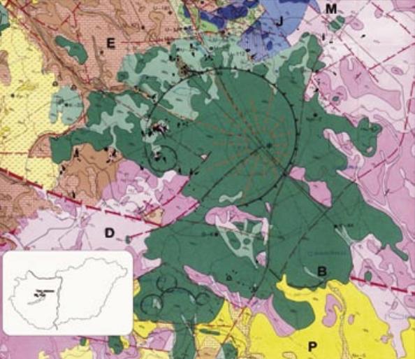
We have conducted our morphological researches on the loess-covered Tési plateau and on the basalt covered karst area around Mt. Kab in the southern part of the Bakony Mts. The nearly 600 m high basalt covered Mt. Kab emerges high from the undulating mountains and hilly areas of the Southern Bakony Mts. Its surface, an area about 35-40 km² is covered by basaltic rocks of different thickness. Pseudokarstic landforms (depressions) developed on the basalt surface due to the karstic corrosion of the buried limestone layers. Grouping the objects of different morphology and evolution rate, and studying in corellation the genetic marks of the significantgroups,a special karst process can be drawn, in which the depressions of various form can be understood as different stations of the same evolutionary series. The Mesosoic rocks building up the 60 km² Tési plateau emerge to the surface rarely above the loess cover. There is agricultural activity on most part of the plateau. Typical covered karstic landforms developed on the 3-5 m thick loess cover. Subsidence dolines or alluvial streamsink dolines with a small catchment area were formed on the summits. We studied the processes, forms and occurrence of recent covered karst of Mt. Bakony, and these studies shows that on the covered karst surface of the Tési-plateau the recent pit formation along with baticapture connected to hidden and real rock boundary, as well as the opening and activation of paleokarstic passages developed before loess formation also play a role in the evolution of the covered karst surface forms of the Tési-plateau.
Downloads
Downloads
Published
How to Cite
Issue
Section
License
Authors guarantee that the work is their own original creation and does not infringe any statutory or common-law copyright or any proprietary right of any third party. In case of claims by third parties, authors commit their self to defend the interests of the publisher, and shall cover any potential costs.
More in: Submission chapter

