
Characterisation of Karst Areas Using Multiple Geo-science Techniques, a Case Study from SW Slovenia
DOI:
https://doi.org/10.3986/ac.v39i1.112Abstract
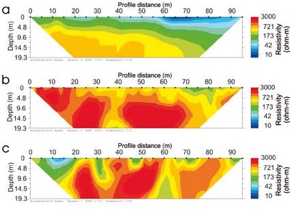
This paper presents utilization of several different investigation techniques to better characterize karst environment. Geomorphological mapping, together with structural and lithological mapping, and electrical resistivity imaging have been carried out in a selected test site in order to evaluate intrinsic characteristics of a karst area. Identification, positioning and quantification of morphometrical properties of karst and other landforms have been determined. Tectonic deformations and lithological contacts of karst and non-karst rock have been precisely located. The extent and depth of the sediments have been examined. The results of mapping and electrical resistivity measurement have been arranged in comprehensive GIS database. The benefit of multiple investigation techniques application has been demonstrated. Employing a combination of methods revealed information on hydrogeologically most sensitive zones that were later used for comprehensive vulnerability and risk mapping, as well as groundwater tracing planning. Gained data provided new achievements in geophysical characterization of the studied area in the western outskirts of the Snežnik aquifer, in particular the Podstenjšek spring catchment. Findings can also be utilized to better understand relief evolution and can serve as a basis for various thematic and applied studies.
Downloads
Downloads
Published
How to Cite
Issue
Section
License
Authors guarantee that the work is their own original creation and does not infringe any statutory or common-law copyright or any proprietary right of any third party. In case of claims by third parties, authors commit their self to defend the interests of the publisher, and shall cover any potential costs.
More in: Submission chapter

